
Portal:Lakes
The Lakes Portal
A portal dedicated to Lakes
-

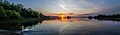
 A view of Lake Teletskoye, the largest lake in the Altai Mountains and the Altai Republic, Russia
 -

-
 A view of West Lake in Hangzhou, China
 -
 A view of Goëngarijpsterpoelen, one of the Frisian Lakes
 -
 Thunder Lake in Northern Alberta
 -
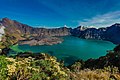
 A view of the six lowest (and largest) lakes of the Seven Rila Lakes

_Goai%C3%AFngarypster_Puollen_(d.j.b.)_20.jpg)
Introduction

A lake is a naturally occurring, relatively large and fixed body of water on the Earth's surface. It is localized in a basin or interconnected basins surrounded by dry land. Lakes lie completely on land and are separate from the ocean, although they may be connected with the ocean by rivers, such as Lake Ontario. Most lakes are freshwater and account for almost all the world's surface freshwater, but some are salt lakes with salinities even higher than that of seawater. Lakes vary significantly in surface area and volume.
Lakes are typically larger and deeper than ponds, which are also water-filled basins on land, although there are no official definitions or scientific criteria distinguishing the two. Lakes are also distinct from lagoons, which are shallow tidal pools dammed by sandbars at coastal regions of oceans or large lakes. Most lakes are fed by springs, and both fed and drained by creeks and rivers, but some lakes are endorheic without any outflow, while volcanic lakes are filled directly by precipitation runoffs and do not have any inflow streams.
Natural lakes are generally found in mountainous areas (i.e. alpine lakes), dormant volcanic craters, rift zones and areas with ongoing glaciation. Other lakes are found in depressed landforms or along the courses of mature rivers, where a river channel has widened over a basin formed by eroded floodplains and wetlands. Some parts of the world have many lakes formed by the chaotic drainage patterns left over from the last ice age. All lakes are temporary over long periods of time, as they will slowly fill in with sediments or spill out of the basin containing them. (Full article...)
Selected article -
.png)
General topics
| Lake zones |
|---|
| Lake stratification |
| Lake types |
| See also |
Need assistance?

Do you have a question about lakes that you can't find the answer to? Consider asking it at the Wikipedia reference desk.
General images -
-
-
 An illustration of ice core drilling above subglacial Lake Vostok. These drilling efforts collected re-frozen lake water that has been analyzed to understand the lake's chemistry. Image credit: Nicolle Rager-Fuller / US National Science Foundation (from Subglacial lake)
 -
 The first view of the sediment at the bottom of subglacial Lake Whillans, captured by the WISSARD expedition. Image credit: NASA/JPL, California Institute of Technology (from Subglacial lake)
 -

-
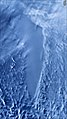
 Titan's north polar hydrocarbon seas and lakes, as seen in a false-color Cassini synthetic aperture radar mosaic (from Lake)
 -
 Lava lake at Mount Nyiragongo in the Democratic Republic of the Congo (from Volcanogenic lake)
 -
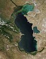
 Soda Lakes in Nevada, USA (from Volcanogenic lake)
 -

-
 Russian scientist Peter Kropotkin first proposed the idea of fresh water under Antarctic ice. (from Subglacial lake)
 -
-
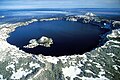
 Round Tangle Lake, one of the Tangle Lakes, 2,864 feet (873 m) above sea level in interior Alaska (from Lake)
 -
 An artist's depiction of the subglacial lakes and rivers beneath the Antarctic Ice Sheet. Image credit: Zina Deretsky / US National Science Foundation (from Subglacial lake)
 -
 The Nowitna River in Alaska. Two oxbow lakes – a short one at the bottom of the picture and a longer, more curved one at the middle-right. (from Lake)
 -
-
-
 A schematic cross-section of the subglacial pool beneath Taylor Glacier and its outflow, Blood Falls. Image credit: Zina Deretsky / US National Science Foundation (from Subglacial lake)
 -
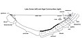 Cross sectional diagram of limnological lake zones (left) and algal community types (right) (from Lake)
 -

-

-
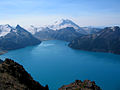 Garibaldi Lake in British Columbia, Canada, is impounded by lava flows comprising The Barrier (from Volcanogenic lake)
 -
 A view of the southern polar plain of Mars. The area where a subglacial lake has been detected is highlighted. Image credit: USGS Astrogeology Science Center, Arizona State University (from Subglacial lake)
 -
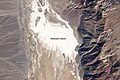
 Ephemeral 'Lake Badwater', a lake only noted after heavy winter and spring rainfall, Badwater Basin, Death Valley National Park, 9 February 2005. Landsat 5 satellite photo (from Lake)
 -

-

-

-
-
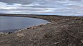
 Lake Mapourika, New Zealand (from Lake)
 -
 Ice melting on Lake Balaton in Hungary (from Lake)
 -
 Crater Lake in Oregon, USA (from Volcanogenic lake)
 -
 View of Lake Toba in Sumatra, Indonesia which is the largest volcanic lake in the world (from Volcanogenic lake)
 -


_2020.jpg)


_and_algal_communities_(right).jpg)


.jpg)


Related portals
WikiProjects

Categories

More articles
| Natural lakes |
| ||||
|---|---|---|---|---|---|
| Artificial | |||||
| Urban Tirana | |||||
| Rivers |  | |
|---|---|---|
| Waterfalls | ||
| Lakes | ||
| Reservoirs | ||
| Glaciers | ||
| Other | ||
Lakes on the Altiplano | |
|---|---|
| Present-day lakes and salt pans | |
| Lake expansions of Lake Titicaca | |
| Ancient lakes | |
| Other paleolakes and lake expansions in the region | |


| Five Great Lakes | ||
|---|---|---|
| Notable freshwater lakes |
| |
| Notable salt lakes | ||
| National Parks | ||
| Protected wetlands | ||
| Nature Reserves | ||
| Major urban lakes | ||
| Reservoirs | ||
| Eastern Georgia |
| ||||
|---|---|---|---|---|---|
| Western Georgia |
| ||||
Great Lakes of North America | |||||||||||||
|---|---|---|---|---|---|---|---|---|---|---|---|---|---|
| Main lakes | |||||||||||||
| Secondary lakes | |||||||||||||
| Bays and channels |
| ||||||||||||
| Waterways | |||||||||||||
| Islands | |||||||||||||
| Historic geology | |||||||||||||
| Organizations |
| ||||||||||||
| Related topics |
| ||||||||||||
| Low-altitude lakes | |
|---|---|
| Mid-altitude lakes | |
| High-altitude lakes | |
| Reservoirs | |
| Related topics | |
| ||
Lakes in Japan | |
|---|---|
| Hokkaido region | |
| Tōhoku region | |
| Kantō region | |
| Chūbu region | |
| Kansai region | |
| San'in region | |
| Kyūshū region | |
|
|  | |
"The Largest Lake in the Philippines" | |||||||
| Location |  | ||||||
| Basin country | |||||||
| Islands | |||||||
| Primary outflow | |||||||
| Primary inflows |
| ||||||
| Settlements |
| ||||||
| Lakes/ponds | |
|---|---|
| Reservoirs | |
Lakes in Mongolia | |
|---|---|
| Lakes |
|
Lakes of New Mexico | |
|---|---|
Lakes and other natural bodies of water in New South Wales, Australia | |
|---|---|
| Coastal lagoons and lakes | |
| Freshwater | |
| Glacial | |
| Salt | |
| Major | |
|---|---|
| Minor |
|
| Artificial | |
| Africa | |||||||||||||||||||||||||||||
|---|---|---|---|---|---|---|---|---|---|---|---|---|---|---|---|---|---|---|---|---|---|---|---|---|---|---|---|---|---|
| Antarctica | |||||||||||||||||||||||||||||
| Asia | |||||||||||||||||||||||||||||
| Europe |
| ||||||||||||||||||||||||||||
| North America |
| ||||||||||||||||||||||||||||
| South America | |||||||||||||||||||||||||||||
| Summary | |||||||||||||||||||||||||||||
Lakes of Switzerland | ||
|---|---|---|
| Major lakes |
|  |
| Lists | ||
| Coastal lagoons and lakes | |
|---|---|
| Freshwater | |
| Glacial | |
| Salt | |
| Man-made reservoirs | |
|  | |||||
|
| ||||||
| Natural lakes |
|
|---|---|
| Artificial lakes | |
| States |
|
|---|---|
| Federal district | |
| Insular areas | |
| Islands |  | |
|---|---|---|
| Cities | ||
| Neighboring lakes and dams | ||
| |||||||||||||||||
| |||||||||||||||||
Associated Wikimedia
The following Wikimedia Foundation sister projects provide more on this subject:
-
 Commons
Free media repository -
 Wikibooks
Free textbooks and manuals -
 Wikidata
Free knowledge base -
 Wikinews
Free-content news -
 Wikiquote
Collection of quotations -
 Wikisource
Free-content library -
 Wikiversity
Free learning tools -
 Wiktionary
Dictionary and thesaurus
External media

- World Lake Database. International Lake Environment Committee Foundation. – provides a searchable database
- Global Lakes and Wetlands Database. World Wide Fund for Nature. – available for free download


